MAGICAL MOUNTAINS
By SCOTT SMITH, THE PUEBLO CHIEFTAIN
Published: Thursday October 06, 2005
Spanish Peaks loom large in fact and folklore
|
On a clear day, looking south from Pueblo, they're impossible to miss.
They majestically hub the distant horizon, stretching skyward like a pair of regal rocky sentinels that mark the place where plains end and mountains begin.
They're a matched set, an alpine version of yin and yang - and some people say they're filled with magic and mystery.
|
|
|
They're the Spanish Peaks, and they're worth getting to know a little better - so here are some facts and folklore to get you started...
|
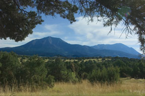
The Spanish Peaks are framed by a pinon pine along Huerfano County Road 340 near La Veta.
Chieftain photos / Bryan Kelsen
|
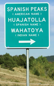 |
NAME GAME
Most people call
them the Spanish Peaks - or Las Cumbres Espanolas. Throughout history, some travelers
also referred to them as Twin Peaks, Dos Hermanos (Two Brothers) or the Mexican
Mountains.
But the majestic mountains also are well known by their American Indian name: Wahatoya
(also spelled Huajatolla, Guajatoyah or Juajatoya), which translates to "breasts of the
Earth." The Ute, Apache, Comanche, Tarahumare and other Indian tribes considered the
mountains to have religious significance as the place where life began and where rain and
sun gods dwelled.
This is from the Ute creation story: |
| The Spanish Peaks are known by many names, including some that
translate to "Breasts of the Earth". |
"Huajatolla are two breasts as round as woman's, and all living things on Earth,
mankind, beasts and plants, derive their sustenance from that source. The clouds are born
there, and without clouds there is no rain, and when no rain falls, we have no food, and
without food - we must perish all." |
ROCK ON
The Spanish Peaks are a geologist's
dream. They are what as known as "stocks," bodies of molten rock that intruded among
sedimentary layers, cooled and solidified, and were later exposed by erosion. The
mountains are made up of large masses of igneous rock: granite, granodiorite and
syenodiorite. But contrary to popular belief, they are not extinct volcanoes.
The peaks are surrounded by a unique formation of basalt dikes that radiate away from
the mountains like spokes of a wheel. There are more than 400 of these ridgeback-looking
dikes, which vary from 1 foot to 100 feet wide and can be as long as 14 miles. The only
other formations on the planet that approximate these nearly perfect forms are found in
Siberia.
ON THE ROAD
The instructions for early travelers navigating the Taos Trail
branch of the Santa Fe Trail went something like this: Keep going west until you see two
big mountains, stay to the north of them, continue west, cross Sangre de Cristo Pass,
drop down into the San Luis Valley and hang a left.
It's a fact: The towering twin peaks - visible from 100 miles away on many days - have
been among the Southwest's most prominent landmarks for a long, long time. The mountains
served as natural signposts that guided American Indians, Spanish and French explorers,
and finally, a flood of settlers. A glimpse of the Spanish Peaks - the easternmost part
of the Rocky Mountains - was often the first confirmation for travelers that they were
indeed about to get up close and personal with the wildest part of the unknown West, the
mountains.
Among those known to have traversed the trails along the peaks: Kit Carson, John
Fremont, John Gunnison, Wild Bill Hickok, William Bent and Tom Breckenridge. The first
non-Indian group known to visit the Spanish Peaks area was the Juan de Ulibarri
expedition, which passed through in 1706 - a century before Zebulon Pike visited Southern
Colorado.
La Veta co-founder John Francisco, upon looking at the valley below West Spanish Peak
in 1862, reportedly proclaimed, "This is paradise enough for me."
PEAK EXPERIENCE
It's a mere 374 feet shy of ranking as one of Colorado's "fourteeners" (peaks at least
14,000 feet in elevation), so West Spanish Peak doesn't get the same use (and overuse) as
its higher-profile brethren. But that doesn't mean an ascent of the peak isn't well worth
the time and energy expended. It is.
The hike to the summit of West Spanish Peak (elevation 13,626) is a good, albeit
moderately strenuous, trip. The trail is a mere 2.7 miles one way, and the first mile is
one of the easiest, most pleasant (pristine forest, sprawling meadows, gnarled
bristlecone pines) stretches of trail you'll ever tread.
But the next 1.7 miles is all pretty much straight up, along a rocky trail/route that
is marked with cairns and not for those prone to wobbly knees or fear of heights.
Although steep in many spots, the trail includes no sections that require technical
climbing skills - just good balance, boots and lungs.
The view from the summit is awesome - truly one of the best top-of-the-world views in
the state. Here's what you can see, looking clockwise from the south: the distant
mountains of New Mexico, Mount Culebra, the Mount Blanca massif, the Crestones, the Wet
Mountains, Pikes Peak, the town of La Veta, East Spanish Peak, and the eastern and
southeastern plains (and New Mexico, Kansas and Oklahoma on a clear day).
East Spanish Peak (elevation 12,683) also can be climbed, although the trail is much
longer and gets much less traffic.
How to get to the West Spanish Peak trailhead:
From Pueblo, take Interstate 25
south to Walsenburg. Go west on U.S. 160 for about five miles until you reach the turnoff
for La Veta on Colorado 12 (also known as the Highway of Legends). Take Highway 12 for
22.2 miles until you reach Cucharas Pass. Turn left at the pass on Forest Road 415, a
dirt road that is passable for most passenger vehicles. Go 6.1 miles until you reach
Cordova Pass. There is plenty of parking area at the pass; the trailhead is on the left.
The hike to the summit and back is about five miles. Note: One mile into the trail, there
is a fork. Take the left branch; the one on the right is the Apishapa Trail, which
traverses between the West and East Spanish Peaks.
TALL TALES?
Legends and lore
surround the Spanish Peaks. Perhaps the most well-known tale is that of Grandote, a
Tarahumare Indian prophet who was seeking gold with his brother-in-law in the peaks.
During a night of restless sleep, Grandote dreamed that his wife, Nina, had died. He
immediately returned to his home and found that the dream was true - Nina had been
poisoned.
Declaring everlasting love and faithfulness to Nina, Grandote returned to the peaks,
where he dreamed of her every night. He remained in the mountains the rest of his life,
serving as the Tarahumares' prophet.
Another version of the Indian legend says that Grandote and his people lived for years
in peace at the foot of the peaks. But one day, a huge rockslide rumbled down the
mountain and buried the village and everyone in it, sealing them in their beloved
homeland forever. Only Grandote survived the slide, and it is said that he still walks
the peaks' canyons and valleys.
Other legends:
Any dream of a person sleeping near the mountain will come true.
No one living in the shadows of the peaks will die.
Giants who lived in the area used to fight one another by throwing boulders; they're
the ones responsible for building the rock dikes that radiate away from the
peaks.
|
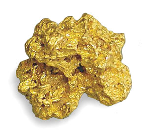
GOLDEN AGE
Once upon a time, there was thought to be gold in them thar hills. Stories of
there being gold in the Spanish Peaks reached as far south as Mexico City, and
Spanish conquistadores were said to have headed north to the peaks in search of
riches. Tales abound of Spanish explorers enslaving Indians and using them to
dig gold from the peaks; most of these stories end with the Indians being killed
after doing all the hard work - and with the Spaniards subsequently being killed
by demons or other Indians and losing their ill-gotten treasure.
|
|
Actually, the Spanish Peaks were the site of numerous, albeit modest-sized, gold
discoveries in the 1870s. Between 1876 and 1878, more than 50 gold mines were staked in
the Spanish Peaks area, but the veins quickly played out and miners moved on to golder
pastures.
 |
SPANISH SAUCERS
Because of their height (more than 6,000 feet above the
plains) and relatively isolated location, the Spanish Peaks are noted for making their
own weather. Thunderstorms often build up around the summits during the summer months,
meaning that hikers and climbers should adhere to the mountaineering safety rule of
getting to the top and heading back down before noon. |
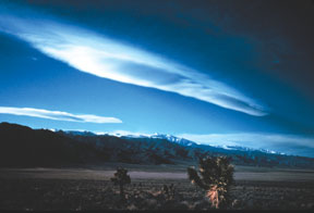
Uniquely shaped lenticular clouds like these are often seen near the Spanish
Peaks.
Courtesy photo / National Park Service |
The peaks also often are a gathering place for lenticular clouds - the smooth-edged,
flying saucer-shaped formations that make you automatically think of UFOs. Hmm, is it a
coincidence that the San Luis Valley - just over the hills to the west - happens to be a
perennial hot spot for UFO sightings? |
CUP SIZE?
Just a thought: Do you suppose landscape artist Christo - he of giant curtains, fabric-encircled
islands and the upcoming Arkansas River art project - would contemplate fitting the
Spanish Peaks (the so-called "breasts of the Earth”) with a giant bra? Maybe
something lacy?
Sources: "The Complete Guide to Colorado's Wilderness Areas," by John
Fielder and Mark Pearson; "Hiking Colorado's Sangre de Cristo Wilderness," by Jason
Moore; "Colorado Mountain Ranges," by Jeff Rennicke; sangres.com; wilderness.net;
visibleearth.nasa.gov; celtictale.com; summitpost.org;
santafetrailscenicandhistoricbyway.org; lavetacucharachamber.com; lavetarealty.com;
sftcbsa.org; American Museum of Natural History.